Aplikasi Android untuk pendaki gunung di JawaAn Android app for hiking Java's mountains
Naik dengan peta. Turun bersama rombongan.Go up with a map. Come down together.
Pilih jalur, rekam pendakianmu dengan GPS, dan tetap bisa ngobrol dengan rombongan lewat Bluetooth dan Wi-Fi saat sinyal hilang.Pick a trail, record your hike with GPS, and keep talking to your group over Bluetooth and Wi-Fi when the signal drops.
File APK sekitar 20 MB, dipasang di luar Play Store.APK file, about 20 MB, installed outside the Play Store.
Contoh rekam jalurExample recording
- WaktuTime
- 3:51
- JarakDistance
- 6,9 km
- NaikClimb
- 1.482 m
Sebelum berangkatBefore you go
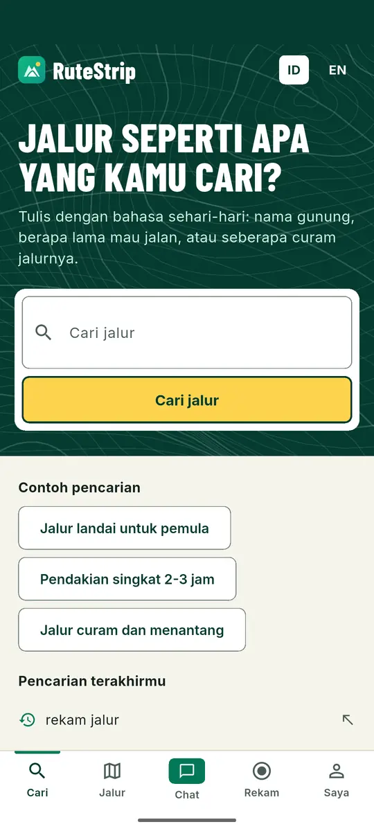
Cari jalur pakai bahasa sehari-hariSearch for a trail the way you talk
Tulis nama gunung, berapa lama mau jalan, atau seberapa curam jalurnya. RuteStrip mencarikan jalur di Jawa yang cocok dan menyusun rekomendasinya.Type a mountain's name, how long you want to walk, or how steep you like it. RuteStrip finds matching trails on Java and lines up recommendations.
- “Jalur landai untuk pemulaGentle trail for beginners”
- “Pendakian singkat 2-3 jamShort hike, 2 to 3 hours”
- “Jalur curam dan menantangSteep and challenging trail”
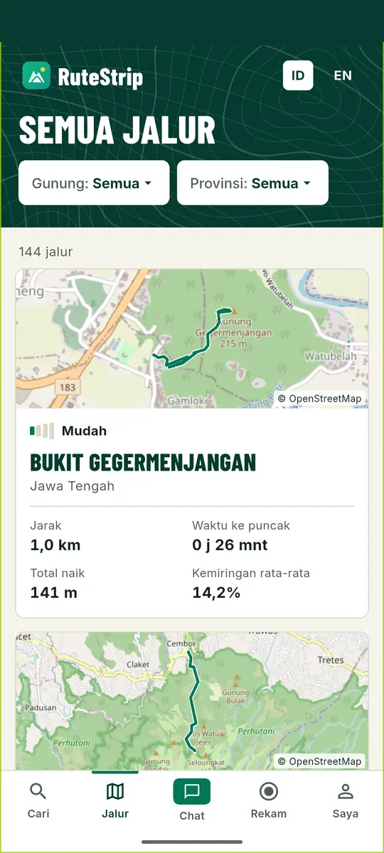
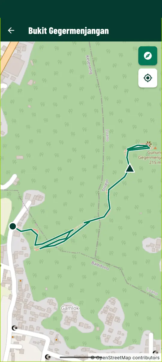
Di halaman tiap jalurOn every trail page
- Peta jalurTrail map
- Garis jalur di atas peta OpenStreetMap.The route drawn on an OpenStreetMap map.
- Profil ketinggianElevation profile
- Lihat di mana tanjakan panjangnya.See where the long climbs are.
- Waktu tempuh NaismithNaismith walking time
- Perkiraan dari jarak dan total naik.Estimated from distance and total climb.
- Cuaca sekarangCurrent weather
- Di basecamp dan di puncak.At basecamp and at the summit.
- Simpan offlineSave offline
- Buka jalurnya lagi tanpa sinyal.Open the trail again with no signal.
- Ikuti sambil merekamFollow while recording
- Jalur tampil di peta saat kamu merekam.The trail stays on the map while you record.
Di jalurOn the trail
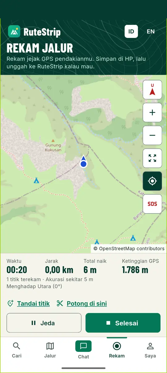
Rekam jejak, layar boleh matiRecord your track with the screen off
Tekan Mulai rekam, lalu masukkan HP ke saku. GPS tetap mencatat dengan notifikasi yang terlihat. Saat kamu membuka layar lagi, peta sudah mengikuti posisimu.Tap Start recording and put the phone in your pocket. GPS keeps logging, with a notification so you know it's on. When you look again, the map is already following you.
- Kompas, peta ikut berputarCompass, map turns with you
- Arah di peta sama dengan arah hadapmu.The map faces the way you face.
- Perbesar dan perkecilZoom in and out
- Lihat simpangan dari dekat.Get close to a junction.
- Angka di bawah petaNumbers under the map
- Waktu, jarak, total naik, ketinggian GPS.Time, distance, total climb, GPS altitude.
- Tandai titikMark a point
- Simpan titik penting di jalur.Save the spots that matter.
Jenis titik yang bisa ditandaiPoint types you can mark
- PosPost
- Sumber airWater
- CampCamp
- PuncakSummit
- BahayaHazard
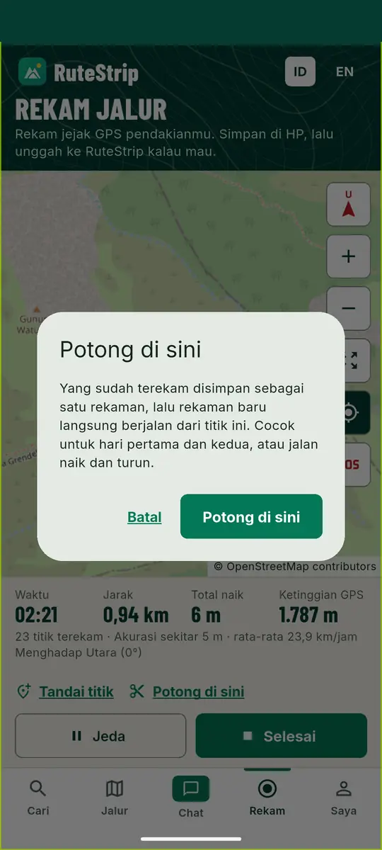
Potong di siniCut here
Mendaki dua hari? Potong rekamannya di camp. Hari pertama tersimpan sebagai satu rekaman, hari kedua langsung jalan dari titik itu.Two-day hike? Cut the recording at camp. Day one is saved as its own track and day two starts recording from that spot.
Baterai habis, jejak amanBattery died? Track's safe
Rekaman disimpan otomatis selama berjalan, jadi jejakmu tidak hilang kalau HP mati di tengah jalan.The recording saves itself as you go, so your track survives if the phone dies halfway.

Jadi jalur baruTurn it into a new trail
Setiap rekaman tersimpan sebagai file GPX. Kalau jalurnya belum ada di RuteStrip, kirimkan. Admin memeriksanya dulu, lalu jalurmu ikut masuk rekomendasi.Every recording is saved as a GPX file. If the trail isn't on RuteStrip yet, send it in. An admin checks it first, then it joins the recommendations.
Saat sinyal hilangWhen the signal drops
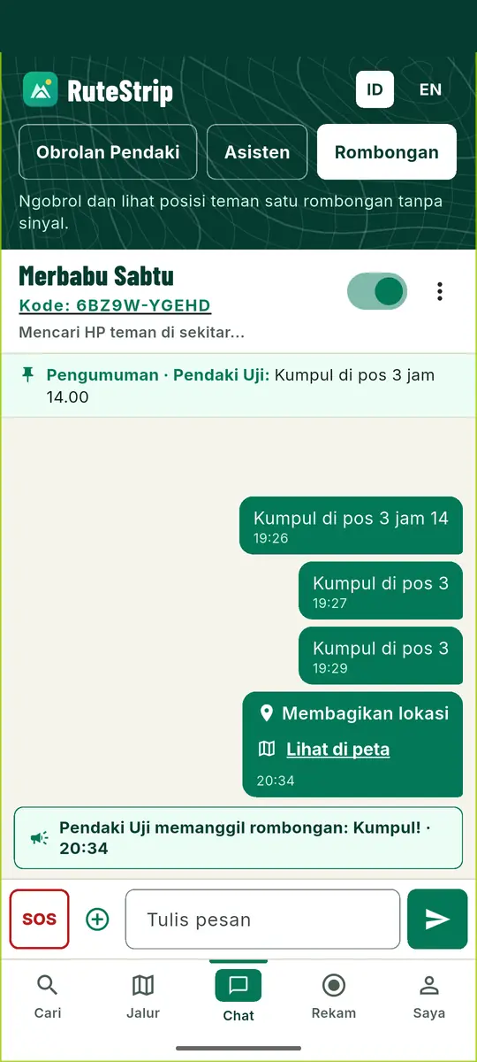
Rombongan tetap ngobrol tanpa internetYour group keeps talking with no internet
HP dalam satu rombongan saling terhubung lewat Bluetooth dan Wi-Fi. Pesan yang tidak bisa sampai langsung akan diteruskan oleh HP teman yang ada di antaranya.Phones in a group connect to each other over Bluetooth and Wi-Fi. A message that can't reach someone directly is passed along by the teammates' phones in between.
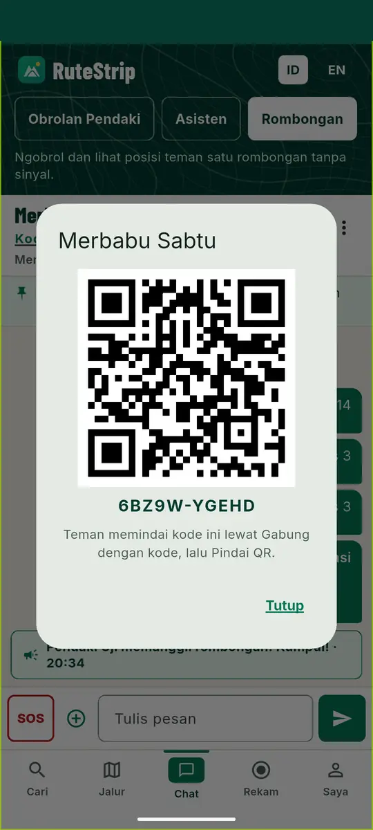
Dikunci dengan kodeLocked with a code
Hanya HP yang punya kode rombongan yang bisa ikut. Pesan dienkripsi dengan AES-256-GCM dan ditandatangani. Teman cukup memindai QR untuk bergabung.Only phones with the group code can join. Messages are encrypted with AES-256-GCM and signed. Teammates scan a QR code to join.
- Obrolan rombonganGroup chat
- Pesan teks antar-anggota.Text messages between members.
- Posisi teman di petaTeammates on the map
- Lihat siapa yang tertinggal.See who's falling behind.
- Kumpul!Kumpul! (regroup)
- Satu ketukan memanggil seluruh rombongan.One tap calls the whole group together.
- Catatan disematkanPinned note
- Misalnya titik dan jam kumpul.Like where and when to regroup.
- Kirim lokasikuSend my location
- Teman bisa membukanya di peta.Teammates can open it on the map.
- Baterai HP temanTeammates' battery
- Tahu HP siapa yang hampir mati.Know whose phone is about to die.
SOS sampai ke seluruh rombonganSOS reaches the whole group
Tombol SOS mengirim tanda darurat ke rombongan, lengkap dengan bunyi sirine. Karena posisi tiap anggota tampil di peta, teman tahu ke mana harus menyusul.The SOS button sends an emergency alert to the group, with a siren. Everyone's position is on the map, so teammates know where to go.
Jaringan rombongan hanya bekerja antar-HP yang saling berada dalam jangkauan. Tetap lapor ke basecamp, dan bawa peluit serta senter.The group network only works between phones that are within range of each other. Still check in at basecamp, and carry a whistle and a headlamp.
Saat ada sinyalWhen you have signal
Ngobrol dengan sesama pendakiTalk trails with other hikers
Fitur di bagian ini butuh koneksi internet, jadi pakai di basecamp atau di rumah.These features need an internet connection, so use them at basecamp or at home.
- Obrolan PendakiHiker chat
- Ruang ngobrol terbuka untuk pengguna RuteStrip.An open chat room for RuteStrip users.
- Asisten RuteStripRuteStrip Assistant
- Asisten AI untuk bertanya seputar jalur dan pendakian.An AI assistant you can ask about trails and hiking.
- Suka dan ulasanLikes and reviews
- Tandai jalur favorit dan tulis ulasan setelah mendaki.Like your favourite trails and review them after a hike.
Ringan untuk HP standarLight enough for everyday phones
Tidak perlu HP mahal. Untuk HP Android lama (32-bit) ada versi tersendiri.No flagship needed. Older 32-bit Android phones get their own build. Unduh versi HP lamaDownload the older-phone build
Pasang RuteStrip di HP AndroidInstall RuteStrip on your Android phone
File APK diunduh langsung dari rutestrip.ai.id, bukan dari Play Store.The APK comes straight from rutestrip.ai.id, not from the Play Store.
Unduh aplikasi AndroidDownload the Android app- HP lama (32-bit)Older phone (32-bit)
- Tidak mau memasang?Rather not install? Buka versi webOpen the web version
Cara memasangHow to install
Unduh file APK, sekitar 20 MB.Download the APK file, about 20 MB.
Buka filenya. Karena tidak lewat Play Store, Android mungkin meminta izin memasang aplikasi dari sumber ini. Izinkan untuk browser yang kamu pakai.Open the file. Since it doesn't come from the Play Store, Android may ask you to allow installs from this source. Allow it for the browser you're using.
Ketuk Pasang, lalu buka RuteStrip.Tap Install, then open RuteStrip.